


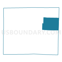
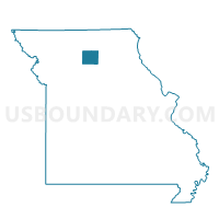
Baker Voting District, Linn County, Missouri
About
Outline

Summary
| Unique Area Identifier | 608994 |
| Name | Baker Voting District |
| County | Linn County |
| State | Missouri |
| Area (square miles) | 46.70 |
| Land Area (square miles) | 46.47 |
| Water Area (square miles) | 0.24 |
| % of Land Area | 99.50 |
| % of Water Area | 0.50 |
| Latitude of the Internal Point | 39.91584700 |
| Longtitude of the Internal Point | -92.92455060 |
Maps

Graphs
Select a template below for downloading or customizing gragh for Baker Voting District, Linn County, Missouri


Neighbors
Neighoring Voting District (by Name) Neighboring Voting District on the Map
- Bucklin Voting District, Linn County, MO
- Ethel Voting District, Macon County, MO
- Grantsville Voting District, Linn County, MO
- New Cambria Voting District, Macon County, MO
- North Salem Voting District, Linn County, MO
- Yellow Creek Voting District, Linn County, MO
Top 10 Neighboring County Subdivision (by Population) Neighboring County Subdivision on the Map
- Bucklin township, Linn County, MO (733)
- Yellow Creek township, Linn County, MO (387)
- Grantsville township, Linn County, MO (257)
- Baker township, Linn County, MO (196)
- Russell township, Macon County, MO (190)
- North Salem township, Linn County, MO (149)
- White township, Macon County, MO (144)
- Drake township, Macon County, MO (72)
Top 10 Neighboring Unified School District (by Population) Neighboring Unified School District on the Map
- Brookfield R-III School District, MO (6,503)
- Linn County R-I School District, MO (1,580)
- Bucklin R-II School District, MO (1,066)
- Macon County R-IV School District, MO (859)